Iceland Travel Guide logo Iceland Travel GuideLOCAL TRAVEL AGENCY IN ICELAND My trip Talk to a local

Þjórsárdalur valley

South IcelandValleyFree entryOpen all year
ÞJÓRSÁRDALUR IN SHORT

Þjórsárdalur is a wide valley in South Iceland at the edge of the highlands, home to waterfalls, lava fields and the ruins of Viking-age farms buried by a volcanic eruption. It is about 120 km (around 1 hour 45 minutes) from Reykjavík, free to explore, and best visited as a half-day loop by car.

ON THIS PAGE
Quick factsHistoryGetting thereSightsBest time to visitSafety tipsFacilitiesMapNearbyWhere to stayFAQ

About Þjórsárdalur

Þjórsárdalur sits along the Þjórsá river, Iceland's longest, at the point where farmland gives way to the highlands near the mountain Búrfell. In the year 1104, Hekla erupted and buried around 20 farms across the valley in thick ash, ending settlement there for centuries. When archaeologists excavated the farm at Stöng in 1939, they found stone foundations preserved almost intact under the ash, which is why the area is sometimes called Iceland's Pompeii.

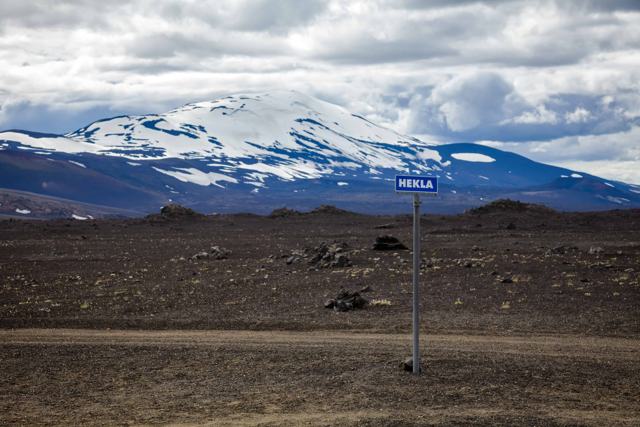
The valley lies in Árnessýsla, between the mountain Búrfell, which stands beside the Þjórsá to the east, and Skriðufell to the west. Further in it splits into two arms, an eastern one at Rauðukambar and a western one along the river Bergólfsstaðaá, towards Sandá. The valley floor is flat and covered in pumice and ash from Hekla, one of Iceland's most active volcanoes, which is in clear view on a good day. Downstream lies Þjórsárhraun, the Þjórsá lava, the largest lava field in Iceland.

Today the valley is a loose collection of sights rather than a single stop: the waterfalls Háifoss and Hjálparfoss, the green oasis of Gjáin, and the reconstructed Viking longhouse at Þjóðveldisbærinn Stöng are all within a short drive of each other. It is a good half-day or full-day route for anyone who wants waterfalls and history together, away from the busiest tourist routes.

Quick facts

RiverÞjórsá, Iceland's longest river
RegionSouth Iceland, at the edge of the highlands
Háifoss122 m high, one of the tallest waterfalls in Iceland
RoadsRoute 32 through the valley (paved); gravel side roads 327 to Stöng and Gjáin and 332 to Háifoss
From ReykjavíkAbout 120 km, around 1 hour 45 minutes by car to the valley
EntryFree to the valley; the reconstructed farm at Stöng has a separate entry fee
Opening hoursThe valley itself is always open; individual sights like Stöng have seasonal hours
Time neededHalf a day to see the main sights

Iceland's Pompeii

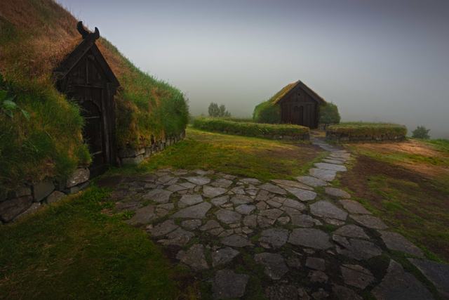
Before 1104, Þjórsárdalur was home to a string of Viking-age farms making a living from the land. When Hekla erupted that year, one of the first eruptions recorded in Iceland's history, thick ash smothered the valley and made it unfarmable. The largest farm, Stöng, was buried so completely that its stone foundations survived almost untouched until they were excavated in 1939, giving archaeologists one of their clearest pictures of how people actually lived in Iceland's early centuries.

How to get to Þjórsárdalur

By carFrom Reykjavík, take Route 1 east, then Route 30 and Route 32 into the valley. Route 32 is paved. The side roads are gravel: Route 327 leads to Stöng and Gjáin, and Route 332 climbs to the Háifoss car park and is rough, so drive it slowly and check whether your rental car is allowed on it.
By public transportThere is no public bus network through the valley, so a rental car is the practical way to explore it.

Roads to Háifoss and further into the valley can be unpaved and occasionally rougher, especially outside summer, so check conditions before setting out.

Natural sites to visit in Þjórsárdalur

The sights are spread along Route 32 and its side roads. These are the main stops, roughly in the order you reach them from the west.

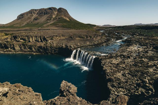
HjálparfossA double waterfall where the river Fossá drops in two streams side by side into a pool framed by basalt columns. It is a short walk from a car park just off Route 32 and the easiest stop in the valley.
Búrfell woodsThe slopes of Búrfell carry birch woodland, a rare thing this close to the highlands. The valley is a good place for plant lovers, with wildflowers, grasses and moss growing out of the pumice.
Þjóðveldisbærinn, the Commonwealth FarmA full-size reconstruction of the Stöng longhouse, built near Búrfell. Fans of Game of Thrones may know it: it was used as the village raided by wildlings in the series. It is open in summer and has an entry fee.
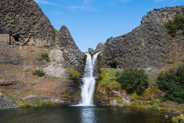
Stöng and GjáinThe excavated ruins of the Stöng farm stand under a shelter at the end of gravel Route 327. From there a path leads to Gjáin, a small green gorge of springs, low waterfalls and lava formations.
HáifossThe river Fossá, a tributary of the Þjórsá, drops 122 m into a deep gorge here, with the waterfall Granni beside it. You look down on both falls from the rim, so keep back from the unfenced edge.
Búrfell power stationThe hydroelectric station at the foot of Búrfell opened in 1969 and was Iceland's first large power project. You pass it on Route 32. The working areas are not open to visitors.

Older guides mention a hot pool in the valley, Þjórsárdalslaug near Rauðukambar. It has been closed for some years. A new bathing place, Fjallaböðin (the Mountain Baths), is being built in the valley and is planned to open in 2028.

Wear proper walking shoes and bring an extra layer and a waterproof, even in summer. The weather at the edge of the highlands can turn quickly, and the paths at Gjáin and Háifoss are uneven. Protect your camera from spray and blowing pumice dust.

The cliffs in the valley are steep and loose. Stay on marked paths and well back from the edges at Háifoss.

Best time to visit Þjórsárdalur

SummerThe easiest time to explore, with all roads normally open and the valley at its greenest.
WinterSome side roads can be harder going or closed after snow, and daylight is limited, so plan a shorter route.

Safety and practical tips

  • Plan a loop taking in Hjálparfoss, Gjáin, Stöng and Háifoss rather than picking just one stop.
  • Check opening hours for Þjóðveldisbærinn Stöng before visiting, since it is seasonal.
  • Some roads further into the valley are unpaved; check conditions if you plan to continue toward the highlands.
  • There are few services in the valley itself, so fuel up and bring water beforehand.
  • Hekla is in view from much of the valley on a clear day. Check the forecast and go when visibility is good.

Facilities and accessibility

No general facilities across the valley; Þjóðveldisbærinn Stöng has toilets when open. The nearest fuel and shops are around Flúðir or on Route 30.

On the map

Open in Google Maps →

Nearby places worth a stop

HáifossHáifossOne of Iceland's tallest waterfallsHjálparfossHjálparfossTwin waterfall in the valleyGjáinGjáinSmall green valley of falls and poolsÞjóðveldisbærinn StöngÞjóðveldisbærinn StöngReconstructed Viking-age farmhouseÞjófafossÞjófafossWaterfall on the Þjórsá, south of BúrfellHeklaHeklaThe volcano that buried the valley in 1104

Where to stay near Þjórsárdalur

Most visitors explore Þjórsárdalur as a day trip. The nearest accommodation is around Flúðir, with more options further along South Iceland's Ring Road route.

Þjórsárdalur FAQ

Is Þjórsárdalur free to visit?

Yes, the valley itself is free; only the reconstructed farm at Stöng has a separate entry fee.

What is there to see in Þjórsárdalur?

Waterfalls including Háifoss and Hjálparfoss, the green valley of Gjáin, and the Viking-age farm ruin at Stöng.

How long does it take to see Þjórsárdalur?

Plan around half a day to see the main sights at an easy pace.

Why is Þjórsárdalur called Iceland's Pompeii?

Because the 1104 eruption of Hekla buried farms in the valley under ash, preserving their foundations for archaeologists to excavate centuries later.

How far is Þjórsárdalur from Reykjavík?

About 120 km, around 1 hour 45 minutes by car.

Was Game of Thrones filmed in Þjórsárdalur?

Yes. The reconstructed Commonwealth Farm, Þjóðveldisbærinn, was used as a village attacked by wildlings in the series.

Is there a hot spring to bathe in in Þjórsárdalur?

Not at the moment. The old Þjórsárdalslaug pool is closed, and the new Fjallaböðin baths are planned to open in 2028.

How high is Háifoss?

Háifoss is 122 m high, which makes it one of the tallest waterfalls in Iceland.

See Þjórsárdalur with a local

Tours and trips that include Þjórsárdalur, booked directly with a local travel agency in Iceland.
Landmannalaugar Super Jeep Tour from ReykjavíkDAY TOURLandmannalaugar Super Jeep Tour from ReykjavíkFrom 46,125 ISK per personLandmannalaugar Private Tour in IcelandPRIVATELandmannalaugar Private Tour in IcelandFrom 207,000 ISK per group
More places in South Iceland